


Imphal Turns Into a Sea Of Water, Nambul Overflows, 28 AR Extends Aid
Source: The Sangai Express
Imphal, October 09 2010:
Almost all the major areas of Imphal particularly Imphal East have been turned into a vast blue of flood water, following the incessant rain during the last three/four days with the Met office recording a total of 33.8 mm of rainfall from Wednesday till Friday.
The worst affected areas include Hatta Golapati, parts of Khurai, New and Old Checkon, Porompat, Nongmeibung, some parts of Wangkhei, the VIP colony at Sanjenthong and adjoining areas.
The tell tale signs of the impending crisis, which were evident in some parts of Imphal last evening, took a turn for the worst when Imphal river started over flowing over a length of 300 to 400 metres at Hatta Golapati area today at about 7 am.
The over flowing quickly inundated the low lying areas and in no time, the flood water had reached chest high at Hatta Golapati area.
Till late into the evening, a large number of people were engaged in moving their assets and properties to higher grounds.
|
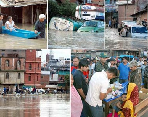
Personnel of 28 Assam Rifles Chinga post, led by its post commander, Major Madhu rushed to the site and extended whatever help they could by way of distributing relief material and conducting a medical camp.
Brigadier Gajendra Prasad, Commander of 9 Sector Assam Rifles, under which the 28 Assam Rifles comes, also personally visited the affected places and over saw the help extended by his men.
IFCD Minister N Biren was sighted for a brief while atop Minuthong.
Imphal river caused the maximum damages in Imphal east areas, with water seeping through the banks and even the retaining walls at several points.
Water seeped through the newly constructed retaining wall at Yaiskul Range at about 20 points, leading to the overflooding of the newly built road, thereby blocking traffic and causing chaos on the busy route.
Till late in the afternoon, all efforts to contact the control room of the IFCD, through the landline number 2451550 and 2452947 went in vain as no one picked up the phone.
However later in the evening a response was received and according to the Control Room, the water level in the major rivers as recorded above mean sea level in metres in the evening today stood at 788.4 at Minuthong (Imphal river), above 783.1 at Lilong bridge (Confluence of Imphal and Iril river), 788.025 at Irilbung bridge and 783.657 at Nambul.
Adding to the woes of the people is the information coming from the Electricity Department.
Speaking to The Sangai Express, the SE (Transmission) of the department said power supply would be cut off at certain areas of Imphal East as the HT wire running along side Kangla Pat has come into contact with the over flowing water from Imphal river.
Imphal river continued to wreak havoc at other places where it runs through, with the western bank of the river developing leaks at numerous points spread across 2 kms approximately at Koirou Mamang Leikai.
The retaining wall built along the river bank could not stop the water from seeping through.
Local MLA Bijoy Koijam visited the affected areas and provided bamboos and bamboo chattais to reinforce the embankments.
A number of leaks developed at the eastern bank of Imphal river stretching from Singjamei bazar to Pebiya Pandit Leikai covering a distance of about 2 km.
Other areas affected in Singjamei area include Bheigyabati and Brahmapur.
The general areas of Kyamgei, Bashikhong and others were also adversely affected, after the banks of the Kongba river caved in at Kongba Irong today at about 6.30 pm.
At Poirou Khongjin in Imphal East district, around five acres of paddy fields have been submerged by the over flowing water from Thoubal river.
This report was received at about 7 pm.
Residential areas nearby including Tulihal, Yambem and Top Chingtha under Andro Assembly Constituency are also getting submerged.
Though there was no report of any river banks caving in or breaching in the early hours of today, the bank of Imhal river gave way at Arapati Awang Leikai in Thoubal district today at 4 pm, affecting a large tract of paddy fields.
The flood water has submerged or affected about 20,000 paris of paddy fields at Kyamgei Muslim, Urup and Arapati.
Till late in the evening, no help from the side of the Government has been forthcoming said locals, who contacted The Sangai Express by phone.
Despite the best efforts put in by the villagers of Arapti Awang Leikai under the over all supervision of the Urup Arapti Development Co-ordinating Committee, till 4 pm today, they could not save some parts of the river banks of Imphal river from caving in, which has led to large scale damages in Arapti Mamang Leikai.
At Irong Khunou of Thoubal district where the Iril and Imphal rivers join, local people were still trying to stop the river banks from breaching or caving in till 4 pm today.
The Nambul river has also overflown at various points, resulting in inundation of large areas at Wahengbam Leikai, Samushang besides affecting Sagolband, Uripok, Tiddim Road, Paona bazar and other localities.
Sega Road, Thouda Bhabok Leikai, where the office of The Sangai Express is located has also been reeling under the increasing water volume which has flooded the road as well as seeped into many households, since last evening.
Parts of Tiddim Road, one of the major roads in the State, were also submerged for quite some time, but by evening, it had started receding gradually.
There is no definite report on the weather conditions in the catchment areas of the river system in the State.
When contacted, a police official from Mao police station said that the downpour stopped at about 4 pm today, but the sky is still overcast.
Our Ukhrul correspondent reports that there was heavy downpour in the last three days, but the condition improved slightly today afternoon.
However nothing can be said with certainty as the sky is still overcast, he added.
 Comment

