


Koirengei Airfield to be developed as State's 2nd airport
Source: Hueiyen News Service
Imphal, November 12 2013:
The Ministry of Civil Aviation, Government of India has taken up the initiative to develop Koirengei Airfield as the second airport of the State.
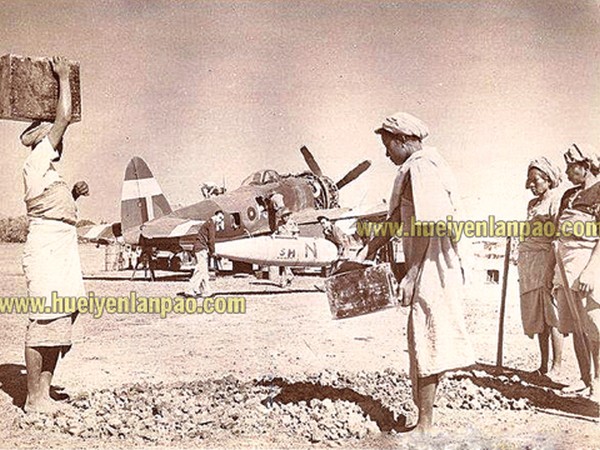
It may be noted that Koirengei Airfield was used by the British troops of Allied Forces during the Second World War.
According to a reliable source, the Ministry of Civil Aviation has been urging the State Government for development of Koirengei Airfield as an airport for quite a long time.
However, the State Government has kept the matter aside saying that the land of Koirengei Airfield now belongs to the Ministry of Defense and it cannot intervene into such matter.
As per the updated information available with Hueiyen Lanpao, the Ministry of Defense has agreed to transfer the land of Koirengei Airfield to Ministry of Civil Aviation in principle.
The actual formalities for the transfer of land are expected to be completed within a short time.
|
The development of Koirengei Airport would require about 690 acres of land.
The required area would be fulfilled by acquiring more than 1000 acres of land belonging to Assam Rifles, Manipur Public School and existing boundaries of the Airfield.
Another source said that the Airport Authority of India (AAI) has requested the Ministry of Civil Aviation to allocate 690 acres of land for development of Koirengei Airport.
However, the Ministry would be able to allocate only 670 acres presently.
The deficit area would be fulfilled by acquiring another 462 acres from the Assam Rifles.
The Ministry of Civil Aviation has already informed the State Government that the Ministry would bear all compensations to be paid to the land owners in the years to come.
The source further mentioned that the transfer of land of Koirengei Airfield from Defense to Civil Aviation would still require the consent of the State Government.
The Ministry of Civil Aviation is in constant touch with the Chief Minister regarding the matter.
Furthermore, the State Cabinet would discuss the matter of Koirengei Airport and its disadvantages to the surrounding in the meeting scheduled tomorrow.
Koirengei Airfield was the site of main camp for refugees fleeing Burma after the Japanese took over in 1942 .
The airfield was also a strategic location for receiving supplies and reinforcement during the Battle of Imphal in 1944 .
There were six airfields scattered around the Imphal Valley in 1944 .
But the three all-weather airfields were Koirengei Airfield, Pallel and Tulihal.
Of these, Koirengei was considered the most important airfield and it can still be seen largely intact along the National Highway No..2Tulihal today serves as the site of Imphal Airport, while a part of Pallel Airfield also survives till today.
The fair-weather airfields, which were essentially carved out of paddy fields at that time, were Kangla, Wangjing and Sapam.
 Comment

