


Stories of Manipuri Rivers
James Oinam *
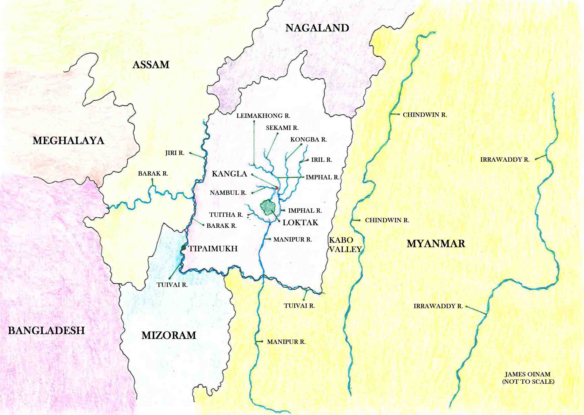
Rivers of Manipur
Rivers have served as socio-economic-political lifeline of Manipur. According to Wangkhemcha Chingtamlen, the Meitei king Garibniwas conducted raids into Burma (Myanmar) up to Irrawaddy River, following the advice of Hindu priest Santidas Gosai.
This resulted in reprisal attacks from Burma along with other reasons [1]. One of the retaliatory attacks by Burma lasted for seven years and is famously known in Manipuri history as 'chahi taret khuntakpa' (meaning 'seven years valley desertation'; common people fled to the hills and to Cachar to escape from Burmese soldiers).
For a brief period, Manipur occupied the Kabo Valley, situated on the west of Chindwin River. It is most likely the rivers acted as natural boundaries and deliberate choice was made to make them political boundaries also.
Jiri River and Barak River form not only natural boundary, but also political boundary between Assam and Manipur states at present on the west. Similarly, the Tuivai River flows in the south along the political border of the state of Manipur.
Imphal River flows on the east of Kangla and forms a natural protection of the capital from enemies coming from east. Two pairs of moats on the southwest and northwest of Kangla served as man-made protections for the capital.
This clearly shows rivers were used strategically by the kingdom of Manipur. The Imphal River was used by Japanese soldiers to reach Imphal during the Second World War [2].
Rivers, brooks and lakes are all considered sacred by the people Manipur. My uncle, who is a maiba (shaman), once told me that Nambul River is an exceptional river of Manipur.
It is the only river that flows right through the Loktak Lake. If you look at the map, you will notice that the other major rivers of Manipur (Imphal River and Iril River) do not flow into the lake. They flow around the lake, on its east. But the Nambul River flows into the lake.
An unknown river emerges from a small lake (?) below the Keibul Lamjao (which forms a part of the Loktak Lake). This unknown river (at least on google map, no name is given) merges with Imphal River coming from east and Tuitha River coming from the west and form the Manipur River which flows into Myanmar. Is this unknown river Nambul River re-emerging from the Loktak Lake as my uncle told me?
According to a Wikipedia article [3], Nambul River was an important waterway for trade and commerce in the past. Some indigenous and endemic fish breed in this river.
Perhaps, it has to do with the fact that it flows into the vast Loktak Lake. But this historically and spiritually significant river is choking in garbage we are dumping into it.
If we have any pride in being a Manipuri (or Kangleicha), we should promise ourselves that we will not throw wastes, especially non-biodegradable wastes like plastics, into this river, or into any river for that matter. There are so many known and unknown reasons why we cannot choke the river to death.
References
[1] Wangkhemcha Chingtamlen. A Short History of Manipur - Part 3. Paochel Kangleipak.
[2] https://en.wikipedia.org/wiki/Imphal_River
[3] https://en.wikipedia.org/wiki/Nambul_River
* James Oinam wrote this article for e-pao.net
The writer is author of 'New Folktales of Manipur' and can be contacted at jamesoinam(AT)gmail(DOT)com
This article was posted on December 27, 2016.
* Comments posted by users in this discussion thread and other parts of this site are opinions of the individuals posting them (whose user ID is displayed alongside) and not the views of e-pao.net. We strongly recommend that users exercise responsibility, sensitivity and caution over language while writing your opinions which will be seen and read by other users. Please read a complete Guideline on using comments on this website.


