


Maps drawn along ethnic lines :: A free for all situation
- The Sangai Express Editorial :: December 04, 2012 -
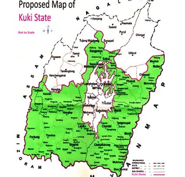
Kuki State Map :: Pix - TSE
Anyone's map can become everyone's map.
A point which must have become clear to all, but obviously which no one is willing to acknowledge.
Drawing a map is not child's play, especially where there are competing claims over land and territory.
Ever since the Kuki State Demand Committee dropped a sort of a bomb shell by coming out with its proposed Kuki map and imposed a public blockade on all routes passing through Kuki inhabited areas, the claims and counter claims, the charges and counter charges, have become more and more vocal.
A clear sign that maps drawn along ethnic lines are sure to churn the cauldron and sharpen the divide along ethnicity.
The proposed Kuki map is of course not the first such map to be drawn up along ethnic line, with the map of Nagalim predatinq it by years.
Two contrasting maps, over lapping into each other's domain, with no common meeting ground visible at the moment.
The only connect between the two maps is the existence of the political entity known as Manipur.
The significance of the two maps may be seen in the backdrop of the reported deal that is likely to be inked between the Government of India and the NSCN (IM) anytime in the near future and the political dialogue that is likely to start between Delhi and the Kuki armed groups under the Suspension of Operation pact.
Not the time for crystal ball gazing exercise and certainly not the time for speculation, but it would certainly be significant and interesting to see how the dice rolls, against the backdrop of the two said maps.
The question is where does this leave Manipur ? To be torn apart by the pressure of pulls and pushes mounted by the two maps ?
Which direction the political dialogue under the SoO pact will take remains in the realm of speculation, but the Kuki National Organisation has more or less made its stand clear.
The concept of Nagalim is also ciear, but with the Government of India sticking to its stand that the territories of Arunachal Pradesh, Assam and Manipur would not be compromised to accommodate the Lim demand; Alternative Arrangement seems to be the answer and this is where the long shadow of doubt and uncertainty arise less than the United Naga Council that the Alternative Arrangement is an arrangement for the Nagas of Manipur, pending a final settlement to the talk between the NSCN (IM) and the Government of India.
The tag, outside the Government of Manipur is also clear.
A window period is what the Alternative Arrangement seems to suggest, but this again takes one back to the question of final settlement.
The entry of the map outlining the proposed Kuki map, at this juncture is what has muddied the water as far as the existence of Manipur as a geo-political reality is concerned.
Maps drawn along ethnic lines can at best pit one ethnic group against the other and this cannot be healthy for anyone.
This is the bottomline.
* Comments posted by users in this discussion thread and other parts of this site are opinions of the individuals posting them (whose user ID is displayed alongside) and not the views of e-pao.net. We strongly recommend that users exercise responsibility, sensitivity and caution over language while writing your opinions which will be seen and read by other users. Please read a complete Guideline on using comments on this website.


