


Zeilad Water Body Complex and Barak Falls
(Gifts of nature of high economy and tourism potentials)
- Part 1 -
Dr H Nandiram / GS Laitonjam *
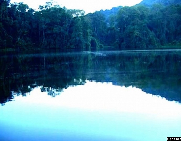
Zeilad lake - Tamenglong - The Natural Paradise :: Pix - Gaikhamdim Marangmei
A trekking team of 9 members of the Adventure Academy of Manipur (ADAM) and The Science Teachers' Forum, Manipur (STFM) left Imphal on the 15th of March (Friday), 2013 on a 5 day trekking itinerary to Zeilad Water Body Complex and Stepped Falls of the Barak and came back home on the 19th of March.
Routes to the destination : Route No.I:- Imphal- Khongsang (on NH-53)- Tamenglong State Highway- Assam Rifles post near Akhui-Akhui Bamgaijang road via Ramlaluang- Bamgaijang-the Barak-Taijijang Village ( on the western bank of Barak)- Zeiladjang village- Zeilad Water Body Complex- Tungtao village- Marui river course- Barak falls just on the northern side of the juncture of the Barak and the Marui.
Route No.II- Imphal- Akhui village-Khongjuron (Chuilon, local name)- Khongjuron waiting shed (newly constructed) at the juncture of 5 river sand quarry routes- the Barak- Vanchengphai/ Valchengphai ( a Hmar village of more than 30 houses) on the western bank- down the river course by canoe (available at Vanchengphai)- Taijijang village-the rest is same as that of the first route.
An alternative route to the Barak Falls:- To Taijijang village by following the routes given above Barak falls area ( down the river course by canoe)- trekking southwards along the western bank ( the right side of the river) through subsided stepped faults- Barak stepped Falls- Marui river course/ Tungtao village Zeiladjang-Zeilad Water body complex.
Route No.III:- Imphal- Khongsang (on NH-53)- keikao- Shempang- Suspension bridge site (construction started but stopped) between the 5th and the 6th falls- Marui river course/ Tungtao village- Zeiladjang- Zeilad Water Body Complex.
Journey:- For onward trekking, the team followed the first route upto Zeilad Water Body Complex and then returned to Taijijang for the journey through the river course given in the route No.2. In the backward journey, six members followed the first route and the other members followed the second route i.e, from the Taijijang to Tamenglong via Vanchengphai.
On the way back the destination of both the parties in Tamenglong was the residence of Ditinchapao pamei a Rongmei team member from Tamenglong HQ. We owe him equally with the villagers of Bamgaijang, Taijijang and Zeiladjang for the valued help and the hospitality which were extended to us throughout the trekking.
Zeilad Water Body Complex :-
I) Napsenzei (Cheng pukhri-rice pond) It measures approximately 6000 sq.m extending from the south-east to the north-west. The surrounding vegetation is very much destroyed under the pressure of Zeiladjang village which is reported to have shifted, some decades back, from Ateng Village on the Western hill range.
II) Nrouzei/Nroujai ( Nrou-bad/tricky, Zei/jai- sacred water) It is bigger than Napsenzei and extending from north-west to south east in an elliptical shape. This water body is associated with the popularly told myth based on tricky pythons. Being an unwanted place often haunted by tricky but cunning pythons, local people enter the area very rarely.
This surrounding vegetation is comparatively, better though aged trees have already been felled and are being felled.
III) Guiphobzei (Guiphob- Turtoise/Turtle, Zei- Sacred water) It is the smallest water body in the complex unlike the other two, it is extending from the west to the north- east direction. ' Duichalam' a brook drains the overflooded water to the Barak. Though degraded, the surrounding vegetation is, still, in regenerating capability. To check further deterioration, it needs protection and non-interference.
IV) Zeilad ( Zei- sacred water, lad-suffix of a man's name) It is generally told that the Zeilad is a corrupt word of Dilatzei'. Being a pool which was under the control of Dilat of Atengba village its name was given as 'Dilatzei' by the villagers of Atengba but in due course it became to be known as Zeilad. It is the biggest water body in the complex. It measures approximately, 30,000 sq.m (200m × 150m approx) and is at an altitude of 160 msl ( according to our altimeter) i.e 50 m higher than the water surface of the adjacent Barak river ( in the month of March).
In size it is little smaller than 'Ningthem Pukhri' ( Wangkhei , Yaiskul Assembly Constituency) dug by Garibaniwaj, the king of Manipur in 1726 to meet the need of potable water of the then villages in and around Kangla, the capital of Manipur. May be knowingly or unknowingly, be that as it may, it was made, in conservation of 'Kongba Leikut' a legendary wetland , about two and half centuries before the emergence of the global concept, 'conservation of wetland of international importance' ( Ramsar Convention. 1971)
The water body is somewhat oval in shape but with wavy margin. The surrounding hills are slopping down to the water. The least gradient northern side is the approach to the water body. This is the side where a perennial brook flows towards the water body. The water is clear, a little acidic, greyish at some parts and deep except the northern shallow portion. We saw many gill nets spreading in shallow water for fishing purpose. The water body is big enough for joy- canoeing.
The surrounding vegetation is representing a degraded status of primary forest, clad with elements of sub-tropical wet and dry forests. The upper part of the western hill and northern region are affected by burning and felling trees. Unless protection measures, to the extent of non-interference, are taken up immediately, under a strict supervision of the surrounding people, its life span may be hastened. It is upto the commitment and consciousness of the local people in particular and people of Manipur in general.
Please be mindful, that 50 years back, the depth of clear water zone of Loktak the biggest fresh water lake in the North East India was around 30m. Presently, its deepest area is only 5m. It may be, still, becoming shallower within a short span of time because the people of this land have no commitment for the conservation of forest in the catchment area of Loktak.
A HEALTHY WATER BODY NEEDS A HEALTHY FOREST IN THE CATCHMENT AREA
Let Zeilad water body complex be not silted from the naked catchment zone to face the fate of Loktak and other dying and dead lakes of the central valley of Manipur.
The location of Zeilad Water Complex is on the western flood plain of the Barak. The area is characterised with sandy loam of the river bed. The depth of the cutting of the flood plain into a narrow course and the height of the flood plain on either side suggest the formation of the complex in the remote past, perhaps before the emergence of man. The view is further strengthened by the presence of drifted rocks around the water bodies. Some of the rocks are peculiar with sign of water action on molten rock material.
To be continued..
* Dr H Nandiram Sharma and GS Laitonjam wrote this article for The Sangai Express
This article was posted on June 12 2013 .
* Comments posted by users in this discussion thread and other parts of this site are opinions of the individuals posting them (whose user ID is displayed alongside) and not the views of e-pao.net. We strongly recommend that users exercise responsibility, sensitivity and caution over language while writing your opinions which will be seen and read by other users. Please read a complete Guideline on using comments on this website.


