
TODAY -


| Off roads on road at Melbourne |
||||||||||||
| By: Chingshang * |
||||||||||||
|
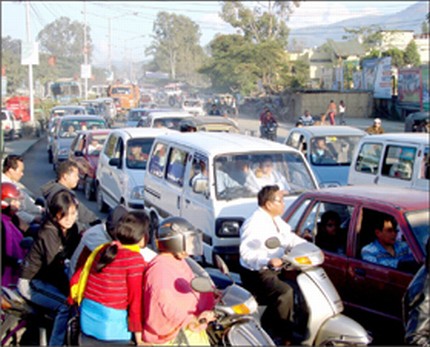
Are we going to plan more of such flyovers in major crossings of the city or is this one going to be the only landmark transportation infrastructure of the state in recent times? Do we have sustainable transportation plans for the future and what are the parameters based on which the plans are going to be implemented? Do we have enough far sightedness in policy plans and decision making process of this evolving state like many in different parts of the world? Do we implement our policies and programs from time to time depending upon the situations? Do we have a vision for the overall improvement of the city? Do we see any coordination between the development of transportation infrastructure and city sprawl in the state over the last few decades or for that matter between different departments? Definitely, official answers to the questions mentioned will be a big Yes or may be just thrown out as worthless questions. The state is growing in terms of its population as well as vehicular traffic. Number of vehicles, big or small, is also increasing per persons. This is a ceaseless ongoing process and continues to high with nasty insensitivity to the states pathetic infrastructures. Its true; everybody can ask beautiful questions and dreaming of beautiful things happening in many parts of the world. But it is also equally true that those beautiful things are the handiworks of its hardworking citizens, may be by utilizing its inherent skills and knowledge or refined knowledge imported from different corners of the world. The later one is very much possible as knowledge can be disseminated very rapidly through different media. As the time passes by, our state has to come to term with the better things happening in different parts of the world. This is a reality which we can not escape away with. At some point of time, we need to take certain amount of risk in order to change the face of the state. But this requires comprehensive planning and a very professional approach where many stakeholders have to play a formative role. Melbourne was founded in 1835, 47 years after the European settlement in Australia. It is a relatively young city which is not older more than 200 years. Today, the city stands tall as worlds most livable city as per the survey of international polling for three consecutive years. The city is also aptly named as the Garden city of Australia like Bangalore the garden city of India. But the gardenity of the two cities is world apart. I have been thinking what factors contribute in making their city the most livable one. Of course, the parameters that were considered for determining it includes attributes like climate, cost of living, Health care, and crime rate and so on. But I have been more impressed by its robust city layout and aggressively planned road network. This is something of an eye-opening for any citizen from a developing country. Well designed roads have one of the most prominent features of the city of Melbourne.
The Central Business District (CBD) which is the hub of Melbourne was designed in 1837 and laid out in Hoddle grid format, after its designer Robert Hoddle. It is laid out in a mile by half a mile format. Later on most of the extensions were prepared from this grid. Almost all the roads can be easily linked to the CBD by following the grid. It is believed that city expansion is taking place in a radial pattern following the main transportation corridors. There are many laneways in the grid which is very convenient for the movement of men and materials. This makes an extremely efficient way of transportation. I have rarely seen a situation which can be termed as traffic congestion or jam in the CBD or in the suburbs so far considering the high number of vehicles plying on the road. They have well maintained traffic signals at all the crossings of the grid. Commuters also strictly followed the signals and laneways. Probably this is one of the factors that contribute in smooth flow of the traffic. Above all their roads are highly pedestrian and cyclists friendly. They have well marked laneways which is strictly meant to serve the same. So you are safe as long as you are on your laneways even if you are commuting in busiest of the roads. It gives a sense of belonging on the road. This is one thing which I really like in this great city. Markings on the roads are very precise and efficiently fits into the grid lock. Practically, there are no flyovers or elevated laneways in the CBD unlike many cities of the world. The various laneways of the grid creates no necessity for this. One can drive through the various laneways with equal ease.
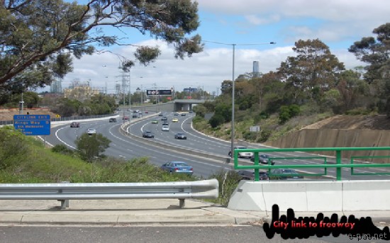
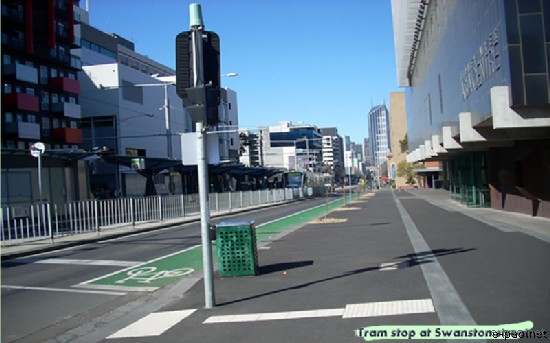
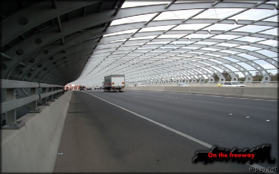
Melbourne has an extensive network of transportation services and their tram service is considered as one of the most enviable ones today. The city and the inner city suburbs are well served by trams which enhance the ease in accessibility, reliability and security of the commuters. As the city is laid out in grid format, commuting on trams is an efficient means of accessibility. Melbournes tram network is one of the worlds most extensive and only one comprising a single line remaining in Australia. It is more of an iconic than just a way of transportation. Some trams are also designated as restaurant trams catering to the high profile tourists Even there is free tram ride for the visiting tourists in the city. The tram encircles the outer boundary grid of the CBD. This an interesting option to find out the CBD area in a jiffy. Basically trams serve as the most efficient means for traveling in the busiest parts of the city. Public commuting on public transport is strongly encouraged. There is strong patronage of public transportation these days especially in the busy metropolitan areas. Melbourne has an efficient ticketing system for public transportation which allows the traveler to commute in all the forms of transportation with a single ticket. It is an integrated system that includes travel by the tram, rail and bus within the specified time mentioned in the ticket. It is very hassle free ticketing system which maximize the travelers convenience in journey. The extensive bus service enjoyed by the citizens is also impressive. There is also free tourist shuttle covering the major landmarks of the city. It operates from 9.30 am to 4.30 pm. Parking is another niche area which is extremely significant in maintaining the efficiency of transportation in the city. Melbourne has a very strict parking system which is well regulated. Pay and park is the order of the day. Parking lots are maintained with automated coin inserting machines which enables you to buy tickets to park. There are many parking spaces both multi storey buildings and open spaces. They are marked with appropriate lines. Parking fees can be paid for the specified timings like 2 hr, 4 hr or say whole day. Even garage sales for parking are quite common here. For a whole day parking in most of the parking spaces cost about 10 A$. There is nothing like you can park your vehicle wherever you like. Traffic controllers strictly observed the parking spaces and they marked the vehicles which are not conformed to the designated spaces. A close observation of the major transport corridors of the city reveals many interesting engagements. It is a highly well planned network of freeways linking to the city at convenient points. Major freeways feeding to the city centre includes Eastern freeway, Monash freeway and Westgate freeway and others like Calder and Hume freeway.
Tullamarine freeway connects directly to the city centre at Elizabeth road. But what is of particular interest to me is their seamless integration with the natural geographical settings. The designers have taken maximum care in planning the infrastructures as it is reflected in the visible space even for a layman. I find that most of the major freeways feeding to the city are constructed along the water courses for a considerable length wherever it is possible. Normally the banks of water courses are free spaces and designers have maximized the space to erect these massive infrastructures and also ensured that this does not affect the normal flow of the channel of water. This is really very interesting and definitely a lesson in urban infrastructure development. Even they have constructed bicycle trails along the water courses and merged with the highway exit points on many counts. This also integrates with rail tracks at convenient points. The superposition of highway, water course and railway wherever possible in their transportation planning around the city is magnificent. This reflects their meticulous planning and comprehensive execution at different stages. One can find even some recreational facilities below the freeway. I know this climbing wall below the city link freeway where youngsters hone their climbing skills on Saturdays and Sundays. I know it is not possible to list out of everything of their transportation infrastructures. It is much more complicated than what I see in a layer. But it is clear that extensive planning taking into consideration of different parameters is the key to its successful implementation. Yes, strong financial strength is needed to erect such infrastructures. But most importantly, the kind of planning and far sightedness of the resultant project gains more momentum. Imphal city has many potential areas where the integration of different transportation forms can be possible to ease its rapidly increasing traffic chaos. Its locational advantages can be maximized to reap the optimum benefit. For example, elevated highways can be thought off linking Khuyathong to Keishampat along the water body and further extensions in stages. There are many parts of the city where extensive planning can be made and executed for future. Of course this will incurred lot of money in the states exchequer and we do not possess that kind of money at the moment. But if we think we can plan for ten years work or fifteen years work, we do not need to have a dream and we will never be better of the same executed elsewhere. Basically ours is a small state where we can plan and execute the things more precisely. You are right. We have host of other things to worry than dreaming and crying in wilderness like this. People will laugh at considering the problems burning in the state now. But you can not escape from the fact that city sprawl is an increasingly continuous phenomena and states population is exploding rapidly whether natural or added. At one point of time or the other, planning for future has to become a part of our growing reality. If not, then we have to live with this inherent feeling of chaos, dirty, worst or what you called or contented with the prevailing face and body of the state. In either case, choice has not been better. But our state has all the potential to become one of the finest. Dont ask me in India or world. Well, the following link (here) gives you good information about Melbourne and you also can browse Google Earth to have an aerial view of the infrastructures. Catch you in the next article. Check out the gallery on Road and Streets in Melbourne here. * Chingshang, a Graduate student at University of Melbourne, contributes regularly to e-pao.net . The writer can be contacted at rockm(at)rediffmail(dot)com . This article was webcasted on November 29th 2007. |
* Comments posted by users in this discussion thread and other parts of this site are opinions of the individuals posting them (whose user ID is displayed alongside) and not the views of e-pao.net. We strongly recommend that users exercise responsibility, sensitivity and caution over language while writing your opinions which will be seen and read by other users. Please read a complete Guideline on using comments on this website.


LATEST IN E-PAO.NET
Jump Start
DBS Imphal SubSite |
Readers Mail |
Editorials |
Education Announcements |
Essay |
Exclusive Event |
Flash - Audio Visual |
Incidents |
LFS Imphal SubSite |
News Timeline |
Poetry |
Opinion |
Sports |
Rock Concert |
RSS |
Top Stories |
Wathi Jugai