


Re-Taking of the Kabo Valley A Possibility?
Wangkhemcha Chingtamlen *

Map of Kabo Valley
Source : Eikhoigi Eereipak by Phanjoubam Tarapot at page 179.
The writer, in this short discourse, will discuss the past history, the present status and the future perspective on the subject mentioned above.
The Past History of the Kabo Valley
(a) During Hindu Rules
You may have seen in the map of Kabo Valley shown above, before 1834,
before the signing of the "Agreement Regarding the Kubo (Kabow) Valley, 1834"
between the commissioners appointed by the King of Ava and the British
commissioners, F.J. Grant, Major and R. Boileu Pemberton, Captain, the eastern
boundary of Kangleipak (Manipur). Now please see the Agreement mentioned
above:

Source : Eikhoigi Eereipak by Phanjoubam Tarapot at page 245
The above Xerox is the "Agreement Regarding the Kubo (Kabow) Valley, 1834". Please read critically the first article "First : The British Commissioner, .....Ningtha Rhoyendau (Chindwin) river", and the last article "Fifth : The Burmese Commissioners......... boundaries now fixed"
This is the position of Kabo Valley after signing this agreement, 1834. No Kangleicha will agree that Kangleipak (Manipur) is a Sovereign Country at this moment of signing this agreement in 1834.
Please mark "Under instruction from the Right Honourable, the Governor- General in Council, ...." Under the first article and "Munnipoorees shall be ordered
........" under the last article at the end of the Agreement.
Please see another agreement:
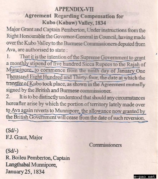
Source : Eikhoigi Eereipak by Phanjoubam Tarapot at page 245
You have seen in the agreement "five hundred sicca Rupees to the Raja Munnipore" is from the British, not from the Burmese Authority. The Agreement is signed at Langthabal Konung. The compensation is given to the Raja of Manipur. It is on 25th Jan., 1834 after the signing of Agreement of giving away Kabo Valley on 9th Jan., 1834 (16 days' span).
Please see written documentary evidence too:
"When Ghumbeer Singh heard the final decision he quietly accepted it, saying 'you gave it me and you can take it away. I accept your decree.' The proposed
transfer was very distasteful to many of the inhabitants"
"The Kubo Valley was handed over to the Burmese on the 9th of Jan., 1834, and on that day Ghumbeer Singh died in Manipur by Cholera." Page 87 of the book, 'Manipur and the Naga Hills' by Sir James Johnstone.
"An attempt was made to negotiate with him, but Major Grant said 'It is no use bargaining with Ghumbeer Singh,' and refused to take any part in it. He was asked
what compensation should be given, and he said 6000 Sicca Rupees per annum." From the same page of the book mentioned above.
From these agreements and historical evidences available since Jan, 1834, Kabo Valley was effectively possessed by the country Burma as owner without any
string or conditions whatsoever. Kabo Valley was bought by the British Authority from the Langthabal Konung by paying 500 Sicca Rupees monthly compensation or 6000 Sicca Rupees per annum as agreed by Gambhir Singh and gave it away to Burma as Gift in 1834 January. This is the position and status of Kabo Valley during Hindu Rules.
(b) Pre-Hindu
"....... in the year 1475, during the reign of Rajah Kyamba; when the refractory tributary of Khumbat, at that time dependent upon the Kings of
Pong, was attacked and expelled from his territory by the united forces of Pong and Munneepor, and the Kubo Valley was formally annexed to the latter country, ....." "Report on the Eastern Frontier of British India" by Capt. R. Boileau Pemberton Page 38.
This same fact is stated by EW.DUN in his book, Gazetteer of Manipur at page 37 also.
The names of the hill 'Angoching' and 'Ningthi Turel' in the Kabo Valley are Kanglei indigenous words, meaning 'Angangching' and 'Beautiful and good river'.
Therefore, Kabo Valley was the land property of Kangleipak, and this cannot be doubted, during the pre-hindu days of Kangleipak up to IInd half of the 18th
Century CE.
Every Kangleicha up to this day knows the fact of political stability of Kangleipak up to the reign of Pamheiba Garivaniwaz in the 18th century CE. Therefore it is no need to write too much about the ownership of the Kabo Valley during the pre-hindu days.
(c) The present position and future perspective of the Kabo Valley.
1. The present position of the Kabo Valley:
After the signing of the 'Agreement regarding the Kubo (Kabaw) Valley, 1834" on Jan. 9, 1834 at Sunnyachil Ghat, on the Ningthi River (Please
see the document above), the Kabo Valley was effectively transferred to and possessed by the country Myanmar (the then Burma). This cannot be doubted, please examine the Agreement. The position of the then King Gambhir Singh was clear too again. He agreed the transfer by demanding compensation.
Please see what he said and reported to be said by him in the book, MANIPUR AND THE NAGA HILLS by Sir James Johnstone (quoted above). After the signing of the 'Agreement Regarding Compensation for Kubo (Kabaw) Valley, 1834' on the 25th Jan., 1834 after the death of Gambhir Singh at Langthabal Konnung, had further confirmed the
transfer of Kabo Valley to Myanmar (Burma) by accepting the compensation by the Langthabal Konnung.
This again cannot be doubted too. The position of the Kabo Valley as a part of Myanmar remained undisturbed up to 1949, when Manipur became a part of the Indian
Country. The event of Merging Manipur to India in 1949 further aggravated the position of Manipur vis-à-vis Burma. The change of political status of Manipur from an independent country to an unit of India further aggravated the position of Manipur vis-à-vis Burma.
From 1949, Manipur cannot do anything in relation to the Kabo Valley with Myanmar (Burma). From October, 1949 anything to be done with the Myanmar Country, whether the Kabo Valley or Trade in Rice even etc lies with the Indian Foreign Office. Therefore, the position of the Kabo Valley upto 2011 as part of the Myanmar Country remains undisturbed even after Manipur became a part of India.
This is the present position and status of Kabo Valley. The Kabo Valley became a part of Burma in 1834, not by Coercion, but by Agreement. Kabo Valley became a part of Burma by consent by all interested parties. This is the present position and status of the Kabo Valley.
2. The future perspective of the Kabo Valley:
The Kabo Valley has been possessed by Myanmar, a foreign sovereign power for 177 years upto this day in 2011, without any illegality raised by any power whatsoever, and no such illegality will be raised in future also by any power, it is thought reasonably, because such a conflict between foreign powers may cost very huge price in the
present political equations in the present Asian situation for a piece of land claimed by Manipur, a neglected State.
From 1949 to 2011 upto this day, India gives consent to the transfer and possession of Kabo Valley by Myanmar since 1834 by Keeping Silence. It is a fact.
Thinking in terms of all probabilities of re-taking of the Kabo Valley by Manipur, the possibility of re-taking of the Kabo Valley by Manipur is zero. The Kabo valley which is about 700 sq. miles which is a little less than Imphal Valley is lost since 1834 CE forever to Kangleipak during Hindu Rule.
* Wangkhemcha Chingtamlen is a frequent contributor to e-pao.net . The sender of this article can be contacted at gcomcc(at)gmail(dot)com
This article was webcasted on September 02 2011 .
* Comments posted by users in this discussion thread and other parts of this site are opinions of the individuals posting them (whose user ID is displayed alongside) and not the views of e-pao.net. We strongly recommend that users exercise responsibility, sensitivity and caution over language while writing your opinions which will be seen and read by other users. Please read a complete Guideline on using comments on this website.


